

Stormy with a chance of data
Stormy with a chance of data
A bit of history, a bit of future, and a bit of present

In the future, the beginning of the Atlantic hurricane season might have been yesterday. (This is seriously the most tenses I could fit into a single sentence).
Currently, Atlantic hurricane season officially begins on June 1st, but tropical weather experts have been discussing whether to move it up to May 15th. As of last year, the U.S. National Hurricane Center began issuing daily tropical Atlantic forecasts on May 15th.
(Yes, I hear you all loud and clear..….do we not even get to celebrate the snow melting before we have to worry about hurricanes?!)
It’s certainly possible that tropical cyclones (the term that includes hurricanes, tropical storms, tropical depressions etc) might be showing up earlier in the spring or later in the fall, on average. There are several reasons for this, including higher sea surface temperatures, and also (interestingly) a decrease in small-particulate pollution - allowing more sunlight to reach the ocean surface. There is also a data question I’ll talk about shortly.
We have also observed an overall increase in the number of Atlantic tropical cyclones since about 1970, but we actually don’t expect tropical storms, globally, to increase in number. Let me say that piece of good news again: the number of tropical systems is not likely to increase, and may even decrease. (I put this in bold too, so you can be even more reassured before I cut off your good news vibe with some bothersome details about hurricane strength and stuff).
However (see?), we DO expect the strongest hurricanes to get stronger, and we definitely expect tropical systems to dump more rain. Hurricane Harvey, in 2017, produced a multi-day rainfall total that likely exceeded any known historical storm in the mainland United States. The rainfall in Hurricane Maria, a month later, was likely even greater than Harvey’s. FEET of rainfall in less than 24 hours. (For those of you who are not still desperately clinging to non-metric measurements as we are here in the U.S. - well over a meter/metre of rain fell in parts of Puerto Rico from Maria).
In any unit of measurement, that’s a nutso1 amount of rain.
But back to the question of whether the official Atlantic hurricane season should begin earlier.
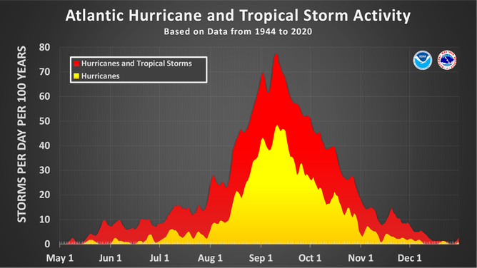
Well, to start with, the official season is just based on statistics. About 97% of storms occur between June 1 and November 30 according to NOAA, but we can see (and have seen) tropical storms and hurricanes outside of the official season - in every month of the year in fact.

In 1935, the National Weather Bureau (the predecessor to the National Weather Service) organized its new hurricane warning network. The telegraph communication system between the hurricane centers was scheduled to operate between June 15 and November 15. It wasn’t until 1965 that the official season expanded to what it is today.
Of course, we monitor the tropics all year round - via satellites, buoys, weather stations etc. But it doesn’t make sense to have ‘hurricane hunter’ planes in the sky or tropical meteorologists issuing daily briefings when the chances are small that there will be a notable storm. So, forecasters base the dates of the season on a balance of best protecting public (and shipping) safety, but not spending unnecessary tax dollars.
So, bottom line: the official season doesn’t mean that it’s the only time we see tropical cyclones, and it also doesn’t make sense to extend the season if we only rarely see tropical cyclones outside of this.
And yet, in every year since 2015, we’ve had a tropical storm occurring in the Atlantic before June 1.
As I say, it’s possible that warmer ocean temperatures will make this an annoying Atlantic habit, so in the US at least, NOAA has put forecasters to work a couple of weeks earlier, and it may also become an official extension. I suspect they will wait a few more years to see if we continue to get named storms before June 1. Our first named storm will be ‘Alex’ this year by the way.
But a final note about data. (Wait, wait, wait! Stay! It’s not boring data!!)
It’s a well-established bit of science that we have historically undercounted tropical cyclones in the Atlantic. This stands to reason - we didn’t get hurricane reconnaissance aircraft until 1944 (still a key source of data in directly measuring hurricane intensity), and we didn’t have satellite monitoring until 1966. And multiple times since the late 1960s, our satellite systems have become better, including as recently as the early 2000s. Also, if someone in 1870 got tossed around by a hurricane in Cuba, it’s not like they could tweet their outrage for us all to see (and our scientists to count).2
So it’s challenging to figure out how much of the apparent increase in the number of tropical cyclones is ‘real’ and how much is an artifact of our gradually improving observing system (and better analysis techniques).
This is particularly notable with short-duration storms. These ‘shorties’ are storms that last two days or less and they make up a significant portion of the apparent increase in overall storms. While sea surface temperatures have increased in the areas where we’re seeing more short-duration storms, the higher temps don’t seem to be well-correlated with when the storms occur. (I guarantee a bunch of scientists went ‘hmmmm’, when they looked at this - always more interesting than finding what you expect).
Short-lived storms don’t directly impact as many people as the long-track storms, so it’s likely that we didn’t ‘notice’ them as much historically. And now that we have satellites looking down on almost every inch of the planet, we pretty much always notice them. In other words, we’re likely counting more of them even if they have not increased (as much) in number.
We have this same challenge with observing historical trends in tornadoes by the way, or really any sporadic, short-lived, and distributed phenomena (like the many and varied places where I leave my phone unintentionally - hard to decipher a trend, though it does seem to be happening more often. Oddly correlated to my increasing age).
So, in summary:
The date of hurricane season might move up a couple of weeks because we have been seeing more May tropical cyclones lately, but the Hurricane Center is at least issuing daily forecasts from May 15th now, which is likely reasonable and helpful.
We have seen more storms in the Atlantic since at least 1970, but might not see a continuing increase in the future - at least we don’t expect to, globally.
Storms are getting wetter though, and strong storms are getting stronger.
And it’s difficult to be precise about the trend in the number of storms, especially the shorter ones, because we have more tools to observe them than we used to.
And if you really want to dig into (fun?) data, check out this paper on whether we take female-named storms less seriously and whether any implicit sexism makes them deadlier (probably not as it turns out).
So I just wanted to bring you a bit of data on hurricanes as we move into the season today, but if you happen to be on the East Coast, or anywhere inland where tropical systems can reach their stormy tentacles, please at least have an emergency kit and plans in place. See FEMA’s advice here.
technical term meaning: honking, mahoosive, whacking, cosmic, ginormous
Though the Jesuit meteorologists in Cuba were perhaps the best in the world at hurricane prediction at this time, much to America’s annoyance.
Thanks, Anne. In Jacksonville, Florida, we are already preparing. November is a long way away.